Best Climbing Apps for Europe 2026 – The Topo, Rockfax & Offline Topos Compared
The Ultimate Comparison: The Topo (formerly 27Crags), Rockfax, Camptocamp, Topo Guru & More
Over the past five years, I’ve tested essentially every climbing app and guidebook resource available for European climbing. This guide cuts through the marketing and gives you real, practical information about the best offline topo apps for European climbing in 2026 — going deep on the two major players (The Topo and Rockfax) and comparing them against strong alternatives like Camptocamp, Topo Guru, The Vertical Life, Windy, Climbing Away, and Mountain Project.
📋 In This Guide
- Why Guidebooks Should Be Your Primary Resource
- The Topo — The European Climbing Standard
- Rockfax — The Professional Choice
- Topo Guru — AI-Powered Route Information
- The Vertical Life — European Climbing Database
- Windy — Professional Weather Forecasting
- Climbing Away — Travel-Focused Climbing Guide
- Camptocamp — The Alpine & European Hub
- Mountain Project — The Global Option
- Head-to-Head Comparison Table
- Which One Should You Choose?
- Frequently Asked Questions
Why Guidebooks Should Be Your Primary Resource — Apps Are Just Support
Here’s the reality that climbers don’t want to hear: apps are convenient, but guidebooks are essential. Guidebooks — especially professionally written ones like Rockfax — are researched, tested, and written by climbers who have spent years at specific crags. Apps are crowdsourced databases that can become stale, inaccurate, or incomplete.
Guidebooks support the local climbing community. When you buy a real guidebook, you’re directly supporting the professional climbers who documented every route, every hazard, every approach detail. You’re investing in climbing infrastructure. When you use a free app, you’re using infrastructure someone built and maintains for free — that’s valuable, but it’s not the same as supporting the people who actually maintain climbing areas and document them professionally.
Guidebooks should be your primary information source. They’re thorough, they’re accurate, they’re vetted. Apps are brilliant companions for the specific moment you arrive at a crag you’ve never been to before — real-time conditions, parking coordinates, beta from other climbers. But they’re complements to guidebooks, not replacements.
The best approach: Buy a guidebook for a region where you climb regularly. Use apps for current conditions, parking coordinates, and beta from other climbers. Together, they create the perfect climbing toolkit.
What Makes Good Route Information Critical
- Protection quality assessment: “This bolt is corroded” or “Protection is sparse above the first anchor”
- Hazard identification: Loose rock, exposed belays, runout sections
- Grade accuracy: Routes graded by local experts, not random internet opinions
- Approach details: Exact directions, parking, descent routes, time estimates
- Local climbing culture: When access is open, what equipment you’ll need, local ethics
- Long-term reliability: Information that doesn’t change because it’s documented
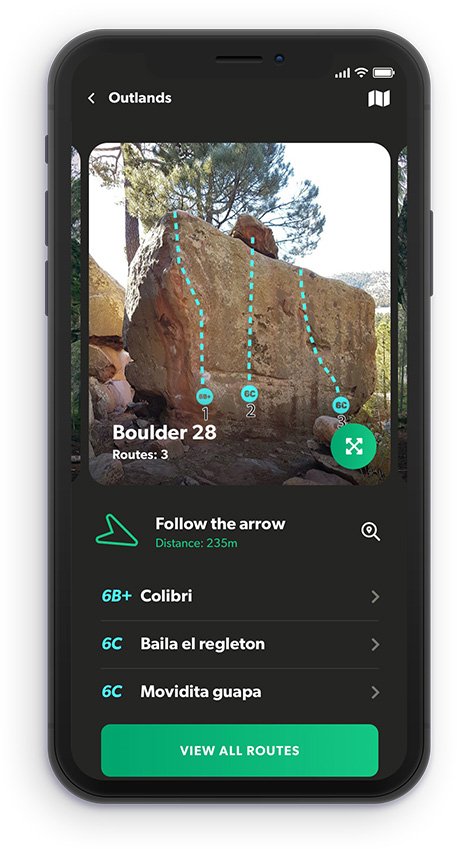
The Topo — The European Climbing Standard
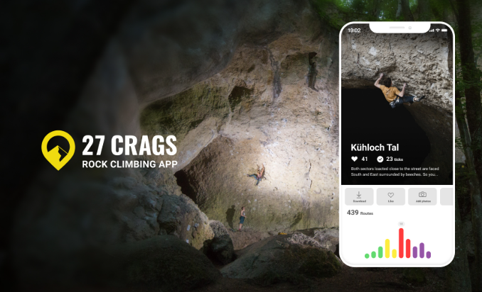
The Topo is the climbing database built by Europeans for Europeans. It’s the first app I open when planning a climbing trip to the continent — built specifically for European climbing culture, grades, and conditions.
The Topo exists because Mountain Project doesn’t serve European climbers well; it’s dominated by North American climbing. The Topo filled that gap with an app built by climbers who actually understand European conditions, bolting standards, and access issues.
The platform runs on two distinct tiers. Verified Premium topos are produced by local climbers, bolters, and guidebook authors who receive 50% of subscription income — the quality is professionally maintained, not crowd-sourced. The free tier consists of unverified community topos: useful for live beta and real-time conditions, but unmoderated, so accuracy varies. Worth cross-referencing with a physical guidebook for complex multi-pitch routes or unfamiliar areas.
- European focus: Every feature designed around European climbing
- Grade conversions: Automatic conversions between French, Spanish, and UIAA grades
- Active community: Real European climbers posting real-time updates
- Access information: Current information about whether crags are actually open
- Parking coordinates: GPS coordinates for exactly where to park — invaluable for vanlifers
- Approach descriptions: Written by people who’ve actually walked the approach
The Topo Features Breakdown
🗺️ Offline Maps
Download crag maps for offline use. Works without data once downloaded. Updated regularly.
📊 Route Logging
Track climbs you’ve done. Build a personal climbing log with photos and notes.
🧗 Topo Images
Verified Premium topos drawn by local authors and kept up to date. Free community topos vary in quality.
💬 Real-Time Updates
Comments on current conditions updated daily — no stale information.
📈 Grade System
Displays routes in European grades (French, Spanish, UIAA). Auto-converts to US grades if preferred.
🔍 Search & Filter
Find crags by location, grade range, and climbing type (sport, boulder, trad).
✅ Pros
- Best European crag coverage of any single app
- Offline functionality actually works
- Real European climber community
- Accurate, current access info
- Correct European grade system throughout
- Free tier available; Premium funds local climbing development
❌ Cons
- Free community topos unmoderated — quality varies
- Some crags have sparse or outdated descriptions
- Not a replacement for a local guidebook at new crags
- Alpine terrain significantly weaker than Camptocamp
💰 Pricing & Plans
- Free version: Access community topos, view routes, live conditions updates
- Premium: €8.90/month or €49.90/year — unlimited verified topos, offline mode, 7-day free trial
Real talk: The Topo is the first app I open for European climbing. The free version gives you the community layer and live conditions. Premium unlocks the good stuff — verified topos made by the people who actually bolt and climb these routes — and your subscription goes straight back into European climbing development.
Rockfax — The Professional Climbing Guidebook Standard
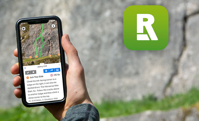
Rockfax has been producing the best-illustrated climbing guides in the UK for over 30 years. Rockfax Digital takes that same meticulous topo quality and drops it into your phone — all 50+ guidebooks, covering 82,000+ routes across 1,645+ crags, for a single monthly or annual subscription.
Rockfax topos are authored by climbers who have spent years — sometimes decades — at specific crags. That shows in the detail: the exact position of a bolt that sits further off-line than the sketch suggests, the descent abseil that becomes dangerous when wet, the route that local consensus has quietly upgraded.
For van lifers constantly on the move, the value proposition is compelling. Instead of carrying a different print guide for every country — or spending £200+ assembling a library before a single season — one subscription covers you from the Peak District to the Dolomites, from El Chorro to Catalunya. Download what you need before you lose signal and you’re sorted, whether you’re parked on a dirt track in the Pyrenees or in a campsite car park in southern Spain.
The app also integrates directly with your UKClimbing logbook — useful if you’re already logging routes on UKC, as one tap records the ascent and pulls real-time feedback from the wider community. Note that you’ll need a UKC account (free to create at ukclimbing.com) to subscribe or use logbook features.
What Rockfax Digital Covers
Coverage is strongest for the UK — every major region is represented — and for the specific European destinations that have received the Rockfax print treatment. French areas include the Ariège, Chamonix, Côte d’Azur, Écrins, Haute Provence, Languedoc-Roussillon, and more. For Spain: Catalunya, Costa Blanca, El Chorro, Madrid, Mallorca, Tenerife, and Zaragoza. Scottish trad, sport, and winter climbing is also included via an SMC partnership.
That said, coverage skews towards the biggest, most-published destinations. If you’re heading to Portugal, the Frankenjura, or much of Eastern Europe, Rockfax Digital won’t help you — and for smaller, off-the-beaten-track sectors it has noticeably less data than The Topo or theCrag, which partner directly with local activists on the ground.
We’ve tested the app in depth — read our full Rockfax Digital review for the complete verdict.🗺️ Professional Topos
High-resolution, hand-annotated topos from Rockfax print guidebooks — fully zoomable, with tappable route lines, pitch grades, belays, and descent information marked up.
📶 True Offline Access
Download crag data in advance — essential for remote venues. GPS navigation also functions offline. Full map directory requires a connection.
📍 Geo-Located Maps
Your exact location shown on detailed approach maps. Genuinely useful when you’re surrounded by trees and cliffs wondering which buttress is which.
📖 50+ Guidebooks in One
Includes the full Rockfax catalogue plus partner publishers — the Scottish Mountaineering Club’s Scottish trad, sport, and winter guides are all included.
🔖 Wishlist & Tick Lists
Save routes and crags for future trips. Bookmark entire sectors or specific routes — useful when you arrive and want to decide based on how you feel that day.
📱 Two Devices Per Account
Works simultaneously on up to two devices — handy for both a phone and a tablet, or sharing between two people travelling together in the same van.
✅ Pros
- Super topo quality — 30+ years of publishing expertise
- True offline functionality — GPS works without signal too
- 82,000+ routes, 1,645+ crags, 50+ guidebooks in one subscription
- SMC partner content — Scottish trad & winter included
- UKC logbook integration — one-tap ascent logging
- 30% off print publications for active subscribers
- BMC members get 15% off annual subscription
- Two devices per account
❌ Cons
- UI feels dated — functional but has a 2015 feel in places
- Coverage gaps outside core areas — Portugal, Ardèche, Frankenjura, Eastern Europe largely absent
- Subscription lapses = no access — unlike a purchased PDF you own forever
- No print/digital bundle — buying the print book gets you no discount on the app
- Intro chapters from print guides not in the app — need separate PDF download
- Storage can add up — up to 2GB per region for newer high-res packages
💰 Pricing & Plans
- Free tier: Browse one sample crag per area — no payment required
- Monthly subscription: £7.50/month — full access to all 50+ guidebooks
- Annual subscription: £60/year — significantly better value for year-round climbers
- BMC members: 15% off annual subscription — verify membership at rockfax.digital before checkout
- Print discount: Active subscribers get 30% off Rockfax print publications
- 7-day free trial available for new subscribers
Van life tip: The annual subscription works out significantly cheaper than monthly — and because you’re probably climbing year-round anyway, there’s little reason to pause it. If you’re a BMC member, verify your membership before subscribing to get the 15% discount applied automatically. One thing worth knowing: if your subscription lapses, all downloaded data becomes inaccessible until you renew. Unlike a PDF you own outright, there’s no permanent ownership here — worth factoring in if you take long breaks from climbing.
Community note: There’s an ongoing conversation in climbing circles about whether subscribing to Rockfax — rather than buying a locally produced topo — directs money away from the bolters and local associations who actually develop and maintain the crags. If you spend extended time in one area, buying the local guidebook directly from the people who bolted the routes is a genuinely good way to give back to the community on the ground.
Topo Guru — Photo-Based Topos with GPS Navigation
Topo Guru takes a different approach to route finding: instead of hand-drawn line diagrams, it uses photo topos with GPS-precise coordinates saved on the spot by local “crag-masters”. Each route line is colour-coded by difficulty directly onto a photograph of the actual rock face, which makes route finding more intuitive at unfamiliar crags — you’re looking at what you’ll actually see when you’re standing in front of it.
The app has partnered with theCrag — one of the largest collaborative climbing databases in the world — giving it access to 88,000+ crags and 900,000+ routes across five continents. For European climbing specifically, the combination of Topo Guru’s photo-topo system and theCrag’s crowdsourced database makes it a genuinely useful tool for lesser-documented areas where The Topo or Rockfax have sparse coverage.
Navigation is one of its strongest features: GPS coordinates are saved for each individual boulder or wall by local partners, and an in-app compass points you to the exact location. For bouldering areas like Fontainebleau or Chironico where finding specific blocks can be genuinely confusing, this precision is worth a lot. The app also includes crag info (rock type, season, parking, nearby accommodation), a climbing log synced with theCrag, and a grade converter.
Note on pricing: Most topos require a paid subscription — the free tier gives access to limited content. Several options are available: STARTER 8€/month, Explorer €12/quarter, Guru €36/year, check each plans on topoguru.com.
✅ Pros
- Photo topos — you see what you’ll actually face at the crag
- GPS precision per boulder/wall — compass navigation built in
- 88,000+ crags via theCrag partnership — enormous database
- Strong for bouldering areas where block-finding is the challenge
- Offline navigation works without mobile signal
- Beta video upload directly from the crag
❌ Cons
- Photo topo quality depends on the local crag-master — varies by area
- Most content behind a paid subscription
- Community-driven — accuracy and completeness not guaranteed
- Less strong on sport climbing route descriptions vs bouldering
- Always cross-reference with a guidebook for multi-pitch routes
Vertical Life — Guidebook-Quality Topos + 8a.nu Integration
Vertical Life has recently merged with 8a.nu — the long-established logbook and ascent-tracking platform — creating a unified profile and logbook across both services. For climbers who already log on 8a, all previous ascents are now in one place.
What sets Vertical Life apart from The Topo is the topo sourcing model. Rather than crowdsourcing route data, Premium topos are authored by local guidebook authors — the same people who write the print guides for specific areas. In many partner guidebooks, a code is included to unlock the digital Premium content in the app. This means the topo quality for covered areas is genuinely close to print guidebook standard, not community-uploaded data of variable accuracy.
The app covers 133,000+ routes across outdoor sport, bouldering, and multi-pitch, and also has a substantial indoor gym component — gym topos, route tracking, challenges, and training plans. For dedicated outdoor climbing travel it’s the outdoor content that matters, but it’s worth knowing the app is built around both use cases.
Not free for outdoor topos: The free tier covers indoor gym content and basic browsing. Full access to outdoor climbing topos, offline downloads, and parking navigation requires a Premium subscription. € 4.99/month / € 59.88 billed yearly after a free 7-day trial vertical-life.info/premium.
- Guidebook-author topos: Premium content written by local experts, not crowdsourced
- 8a.nu merger: Unified logbook — all your previous 8a ascents carry over
- Parking navigation: Direct tap-to-navigate to crag parking (Premium)
- Offline access: Download crags for use without signal (Premium)
- Guidebook codes: Physical guidebook purchases often include an unlock code for the app
- Revenue share: A portion of subscription income goes back to local crag developers
✅ Pros
- Guidebook-author topo quality — not crowdsourced
- Merged with 8a.nu — unified logbook for existing 8a users
- 133,000+ routes worldwide
- Revenue share supports local crag developers
- Guidebook unlock codes — adds value to print purchases
- Clean, well-designed interface
❌ Cons
- Outdoor topos require paid Premium — not free
- Smaller coverage footprint than The Topo for lesser-known crags
- Indoor-focused features may feel like bloat for pure outdoor climbers
- Less real-time community beta than The Topo
Windy — Professional Weather Forecasting for Climbers
Windy is a professional-grade weather forecasting service that has become invaluable for outdoor sports enthusiasts across Europe. Originally designed for meteorologists and pilots, it’s now used by climbers to predict rock temperature, humidity, wind conditions, and weather windows with exceptional accuracy.
- Hyperlocal forecasts: Check weather at your exact crag coordinates, not just town forecasts
- Rock temperature predictions: See predicted surface temperature — critical for planning climbing days
- Wind data: Understand wind patterns that affect exposed crags
- Humidity tracking: Know humidity levels to predict friction and rock conditions
- Extended forecasts: 14-day outlooks help plan climbing trips across Europe
- Free version available: Premium version adds additional features
✅ Pros
- Professional-grade accuracy
- Hyperlocal weather data
- Rock temperature predictions
- Excellent for trip planning
- Free basic version
- Trusted by outdoor professionals
❌ Cons
- No route information
- Learning curve for new users
- Premium features cost money
- Requires a separate app from route finder
- Web-focused — mobile app less polished
Best for: Climbers who need accurate weather forecasting to plan trips across Europe. Essential for vanlifers — use alongside The Topo to combine route info with weather planning.
Climbing Away — Travel-Focused Climbing Guide
Climbing Away is designed with climbing travellers and vanlifers in mind, combining essential crag information with travel guides, accommodation, and trip planning.
Community-driven platform: It operates similarly to Wikipedia, relying on user contributions for its climbing data and travel tips. Excellent for finding nearby amenities and planning your journey, but cross-reference specific route information with a dedicated climbing guidebook or The Topo for accuracy on the rock.
- Climbing + travel: Routes plus where to sleep and eat
- Trip planning: Complete climbing travel itineraries
- Accommodation info: Campgrounds, hotels, parking for climbers
- Local guides: Travel advice for climbing regions
- Community tips: Climber recommendations for areas
✅ Pros
- Travel-integrated planning
- Perfect for vanlifers
- Accommodation info included
- Complete trip planning
- Active traveller community
❌ Cons
- Route info less detailed than dedicated apps
- Not a primary route database
- Smaller climbing database overall
Best for: Climbing travellers and vanlifers who need integrated trip planning.
Camptocamp — The Swiss/European Outdoor Community Database
Camptocamp began as a Swiss-centric database but has evolved into a comprehensive outdoor resource for the entirety of Europe — a community-driven platform with strong moderation, specifically tailored for serious mountain adventures.
- Alpine climbing focus: Unrivalled for Alpine, mixed terrain, and ski mountaineering
- Professional review: Routes frequently reviewed and updated by active, experienced climbers
- Multi-language: French, German, Italian, and English support
- Free and open: Completely free with no paywalls
✅ Pros
- Excellent for the Alps and alpine objectives
- Good mixed climbing info
- Professional moderation
- Multi-language support
- Completely free
❌ Cons
- Weaker on sport climbing
- Less comprehensive database for Mediterranean areas
- Alpine strong, sport climbing weak
- Smaller community for non-alpine routes
Best for: Alpine and mixed climbing — Switzerland, French Alps, Dolomites.
Mountain Project — The Global Database
Mountain Project is the massive, crowdsourced climbing database covering North America brilliantly and the rest of the world inconsistently. It’s free, it’s huge, but for European climbing specifically, it’s less useful than The Topo or Rockfax.
Why Mountain Project Falls Short in Europe
- North America focus: Built for US/Canada climbers — European climbing gets left behind
- Grade confusion: Mixes American and European grades without clear conversions
- Stale information: No requirement for updates; old beta persists
- Inconsistent detail: Some crags have deep info, others have almost nothing
Bottom line: Mountain Project is useful as a backup or secondary resource for Europe. Don’t make it your primary European climbing tool.
📊 Head-to-Head Comparison Table
A quick reference across all the major climbing guidebooks and apps for European climbing.
| Tool | Type | European Focus | Offline | Cost | Best For |
|---|---|---|---|---|---|
| The Topo | App | ⭐⭐⭐⭐⭐ | ⭐⭐⭐⭐ | Free / €8.90mo / €49.90yr | European climbing discovery |
| Rockfax | Guidebook/PDF | ⭐⭐⭐⭐ | ⭐⭐⭐⭐⭐ | £10–25/region or £47/yr | Professional detailed route info |
| Camptocamp | App/Web | ⭐⭐⭐⭐ | ⭐⭐⭐ | Free | Alpine and mixed climbing |
| Topo Guru | App | ⭐⭐⭐ | ⭐⭐⭐ | Free | AI-powered route discovery |
| The Vertical Life | App | ⭐⭐⭐⭐ | ⭐⭐⭐ | Free | Quality-vetted European topos |
| Windy | App/Web | ⭐⭐⭐⭐ | ⭐⭐⭐ | Free / Premium | Professional weather forecasting |
| Climbing Away | App | ⭐⭐⭐ | ⭐⭐⭐ | Free | Travel-focused trip planning |
| Mountain Project | App/Web | ⭐⭐ | ⭐⭐⭐ | Free | Global (not Europe-focused) |
Ready to Climb Better With the Right Tools?
Frequently Asked Questions
Is The Topo better than Rockfax?
Do climbing apps work without signal?
Which climbing app has the best GPS navigation?
Is The Topo Premium subscription worth it?
What’s the best climbing app for van life in Europe?
🧗 Explore Our Climbing Guides
Detailed crag guides from our van life climbing adventures across Europe